Research and Practice
Supporting the use of telecom data to inform the COVID-19 response efforts
- A conference paper for the 5th International Conference Data for Policy 2020. It summarizes our approach for building a data ecosystem for using telecom data to inform the COVID-19 response efforts.
Telecom data can be useful for informing the COVID-19 response efforts
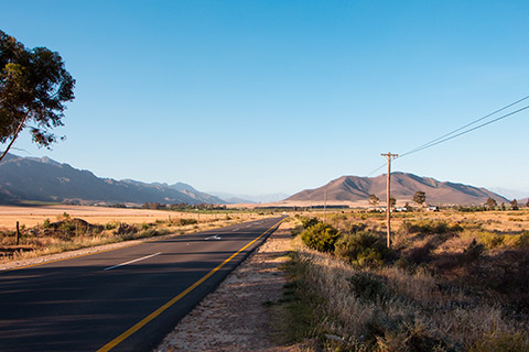
The date of the diagnosis lags the date of onset of symptoms, which itself lags the date of infection. It is challenging to inform the COVID-19 response efforts with the lagging diagnostics alone. Telecom data cover a large part of populations even in less developed countries. The data include the time and associated cell tower location of network events, such as calls and SMS, thus can be used to understand mobility patterns and human behavior.
Telecom data can provide insights on the time-varying distributions and footprints of subscribers at the cell tower level. Because the data are passively collected in near-real-time, it can be used to produce time-varying indicators of mobility patterns. Such indicators can help us answer the following questions that can potentially inform the COVID-19 response efforts:
- How many people visited hotspots? Where did they come from? Where did they go afterward?
- How the restriction impacted population movements? How many people are still away home and for how long?
How we can support
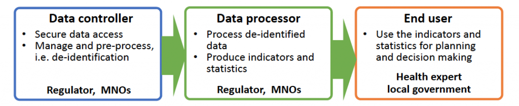
We work with various stakeholders to help use telecom data to inform decision making and planning for the public good. We support the regulators and mobile network operators (MNOs) to establish a data pipeline that enables to extract data on mobility patterns and human behavior without compromising existing systems on the premise of the data controller. Entire support can be provided remotely.
Technical support we can provide
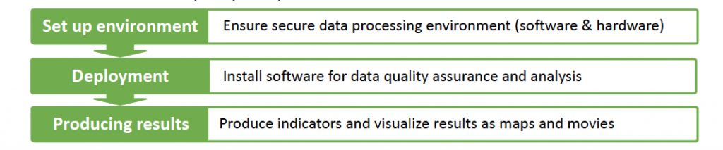
We provide the following support to establish the data pipeline that produces indicators and visualizations from de-identified telecom data:
- Provide open-source software – Mobipack – that enables mobility analysis and visualization using de-identified telecom data.
- Set up a Hadoop-based system to run programs/software such as Mobipack as well as any other software developed by third parties.
Data security and processing environment
- Any identifies are encrypted in an irreversible manner. No personally identifiable information is included in the data used for processing and producing indicators.
- Telecom data are processed on the premise of the local government. Data are never brought out of their system in their country. The data are managed by the regulator or MNOs in a safe and responsible manner.
Use cases
Our ongoing efforts for supporting the COVIS-19 response include the analysis and visualization of the following indicators on a daily basis in African countries:
- Headcounts of subscribers at the district level (daytime and night-time)
- Headcounts of subscribers who are away from home during the daytime (before and after the restrictions) at the district level
- Inter-district ODs (Origin-Destination) of all subscriber
- Median travel distance at the district level
- Average radius of gyration at the district level
Information to Combat the Ebola Epidemic – Sierra Leone, Liberia, and Guinea
Big Data for Development: Preventing the Spread of Epidemics
Data from mobile phone operators are particularly valuable in cases of emergencies, such as Ebola virus outbreaks, because the mobile-cellular network is nearly ubiquitous and a growing number of people are using mobile phones.
We leveraged the CDR data of three neighboring countries to understand how cross-border human mobility impacts the spread of infectious diseases such as Ebola. We identified high risk areas for neighboring countries in a cross-border human mobility setting. This project showcased the potential for mobile data to facilitate the timely exchange of information to combat the Ebola epidemic and future health crises. As part of this project, we conducted capacity building for ten mobile network operators and network authorities who provided CDR data for this project.
https://www.itu.int/en/ITU-D/Emergency-Telecommunications/Pages/BigData/default.aspx


Complementing Conventional Population Data – Sri Lanka, Mozambique
Dynamic Census Project – Frequent and Glanular Population Mapping
 Censuses comprise a primary data source for decision making, a fact that has been well-accepted and validated by rigorous methodologies. However, a census requires enormous time and financial resources to update. More granular and timely data are needed to address global issues, which are closely related to dynamic pictures of human activities, and to enable the systematic progress reviews of SDGs but not yet realized. Mobile phone data have been considered a novel source for passively collected data, thereby enabling new approaches to obtaining demographic measurements.
We utilized CDR data to produce a Dynamic Census that reveals the movements of all individuals in a population over time broken down by age and gender to provide granular and frequent population mapping data. Through these projects, we developed methodologies to address four major limitations of CDR data; non-constant temporal resolution, non-uniform spatial resolution, representativeness biases, and data anonymity.
Collaborators: LIRNEasia (Sri Lanka), Eduardo Mondlane University (Mozambique)


Lowering the Implementation Cost of Surveys for Road Maintenance – Mozambique
Intercity travel volume, link-based speed, and road roughness conditions in Southern Mozambique
 The cost of data collection required for road maintenance and planning is a burden for resource-poor countries because it requires significant human resources, time, and high-end devices.
We utilized CDR data to develop a predictive model that estimates the intercity travel volume, link-based speed, and its relationship with road roughness conditions, which could help road authorities lower the costs of monitoring road conditions. We analyzed CDR data by combining them with the road roughness conditions that were evaluated based on the International Roughness Index (IRI) and a smartphone application, BumpRecorder*.
* BumpRecorder is a smartphone application that measures pavement roughness.
Collaborator: Road Fund, National Road Administration


Human mobility pattern analysis – Rwanda
Pilot Study (ongoing)
 The digital footprints left by mobile phones can be gathered, analyzed, and used to develop better policies and provide critical information in emergency circumstances. We have been conducting a pilot study to understand how we can utilize CDR data to control the spread of infectious diseases. This is an ongoing project and part of the Cooperation of Space Science, Earth Science, Satellite Development, and Geospatial Data Processing between The University of Tokyo and the Rwanda Utilities Regulatory Authority.
Collaborators: Rwanda Utilities Regulatory Authority, Space Edge Lab. Co.,Ltd

Understanding Human Mobility Seasonality – Bangladesh
Project on the Revision and Updating of the Strategic Transport Plan for Dhaka
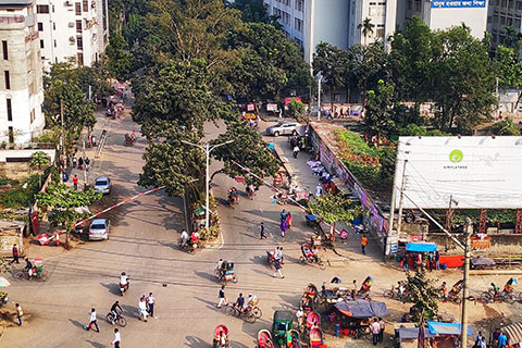 We analyzed CDR data to quantify regional human mobility in Greater Dhaka. Analysis results revealed human mobility seasonality in wet and dry seasons and a high correlation in Origin-Destination (OD) between the conventional transport survey and the CDR analysis results. It also indicated some discrepancies, which were related to seasonal factors.
Our study was used as part of the supplemental survey to review and modify the existing Strategic Transport Plan (STP) intended to address the projected transportation needs of future developments.
http://open_jicareport.jica.go.jp/pdf/1000029080.pdf

Reconstructing Human Mobility Trajectories for Urban Planning and Disaster Management – Turkey
Geospatial Platform for a Disaster-Resistant Society and High-Quality Electronic Communication Services Feasibility
 This study was part of the analysis conducted for a feasibility study regarding the development of a system for disaster management. We used CDR data to extract information supporting urban planning and disaster management by reconstructing and visualizing trajectories. We also analyzed population distribution changes, major ODs, and individual dwelling times for the target areas selected, which can be used for route, visitor, and heat map analyses.
Collaborators: Ministry of Internal Affairs and Communications, Japan
Data for Continuous Monitoring and Evaluation – Sri Lanka
A Mixed Method Approach Leveraging High Frequency Data to Understand Transport in Sri Lanka (ongoing)
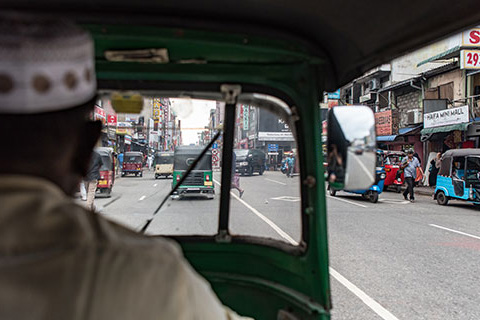 Weaknesses in transport and logistics infrastructure and planning is one key factor constraining growth in Sri Lanka. In particular, bottlenecks resulting in traffic congestion in the Western Province and the slow movement of people, goods, and services between the Western Province and other regions are serious constraints. The rapid collection of time-sensitive data is needed to better understand and address these problems.
This project aims to develop methodologies and use data to establish a baseline measurement of KPIs for future monitoring and evaluation purposes. The outcomes of this project will facilitate the creation of longer-term capabilities and structures to facilitate both the access to and utilization of new data sources for continuous monitoring and evaluation of transportation related interventions.
Collaborators: LIRNEasia, University of Moratuwa, University of Wollongong


Supporting Better Traffic Planning and Proactive Management – Egypt
Sensing and Analysis of Human Mobility (ongoing)
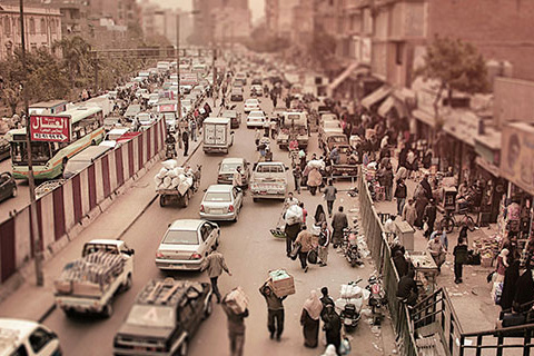 Cairo’s metropolitan area is the largest in the Middle East and the Arab world with a metropolitan population of 20.5 million inhabitants. Like other mega-cities, Cairo suffers from high levels of pollution and traffic, the latter of which generates over 1 billion annual passenger rides.
We use CDR data to support traffic planning and operation and enhance the proactive management of traffic in Cairo city. The project proposes the use of a multi-tiered approach to establish a coherent framework called the Sensing and Analysis of Human Mobility (SAHM). The framework integrates data from different sources, including the CDR data, transportation networks, land-use data, and zoning systems.
Collaborators: Cairo University, Ministry of Transportation


Mapping Informal settlements – Egypt, Peru, China, Indonesia, India, Kenya
Study on distribution and transition tendency of informal areas in cities (ongoing)
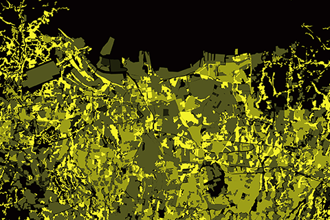 Over 30% of the urban population in developing countries lives in informal settlements. Because the living conditions are directly linked to their well-being, accurate data that can be used to facilitate an understanding of settlement patterns and urban structure are significant for reducing urban poverty.
In this work, we adopted remote sensing imagery based on a visual interpretation method to map four urban forms within six cities – Cairo, Lima, Guangzhou, Jakarta, Mumbai, and Nairobi – with a range of 50 km×50 km for each city. The four urban forms are mapped by the degree of informality with a pixel size of approximately 0.54 m×0.54 m.
The data obtained from each city are integrated into a dataset named GeoMorpho. This study introduces GeoMorpho and the corresponding interpretation methods, which could serve as viable tools for research in fields such as urban mapping, land-use classification, and urban morphological structure analysis with high accuracy and efficiency.
Capacity Building
The public sector has been a major player in the provision of primary data sources for decision making. Today, the volume of data in the world continues growing exponentially; many of the big data originate within the private sector. Most big data are generated passively and used for commercial purposes. Such data, including mobile data, are found to be useful data sources for improving social welfare because they can potentially provide better and more timely indicators for measuring changes in people’s living status and behavior. However, it is often difficult to access such private-sector data because they are typically passively collected for limited operational purposes and are sometimes vulnerable to competitors. There are also different levels of knowledge, capacity, skills, and incentives required to utilize mobile data, depending on the goal and responsibility of the organizations involved in a given society. We will help narrow these gaps through capacity building, which will facilitate more optimal access and use of mobile data in the long run. We expect that capacity building can help reveal the hidden value of the data, and enable organizations to utilize it not only for the social welfare but also for the data holders themselves. Capacity building was conducted in the following countries:
- Sierra Leone
- Liberia
- Guinea
- Mozambique
- Rwanda
For data users
- We introduce the concept of Mobile Data for Development by showcasing use cases in development practice. These use cases include examples of information and statistics, which can be extracted from mobile data using open technologies.
- We collaborate with local governments to explore ways to utilize mobile data to address the development problems they face. We co-create project proposals for pilot projects.
- We facilitate partnerships with data holders to enable data access.
For data owners, data producers, data users
- We introduce the concept of Mobile Data for Development by showcasing use cases in development practice. These include examples of information and statistics, which can be extracted from mobile data using open technologies.
- We introduce the knowledge and technologies necessary for processing and analyzing mobile data, including tutorials with hands-on opportunities for practice using Hive.
- We provide open-source software, CDR Data Analysis Package, which enables those who wish to utilize mobile data for improving social welfare to produce statistics, figures, maps, and movies. We provide hands-on opportunities to use the software.
Publications
Coming soon.